Marktwachstum, Größe, Anteil, Trends, Analyse der wichtigsten Akteure und Prognose für Fernerkundungsdienste bis 2031
Marktgröße und Prognose für Fernerkundungsdienste (2021 – 2031), Bericht über globale und regionale Anteile, Trends und Wachstumschancenanalysen: Nach Auflösung (spektral, räumlich, radiometrisch und zeitlich); Plattformtyp (Flugzeug, UAV, Satellit und Boden); Endbenutzer (kommerziell und Verteidigung) und Geografie
- Status : Veröffentlichte Daten
- Berichtscode : TIPAD00002464
- Kategorie : Luft- und Raumfahrt und Verteidigung
- Anzahl der Seiten : 150
- Verfügbare Berichtsformate :


- Datum der letzten Aktualisierung : February 15, 2025

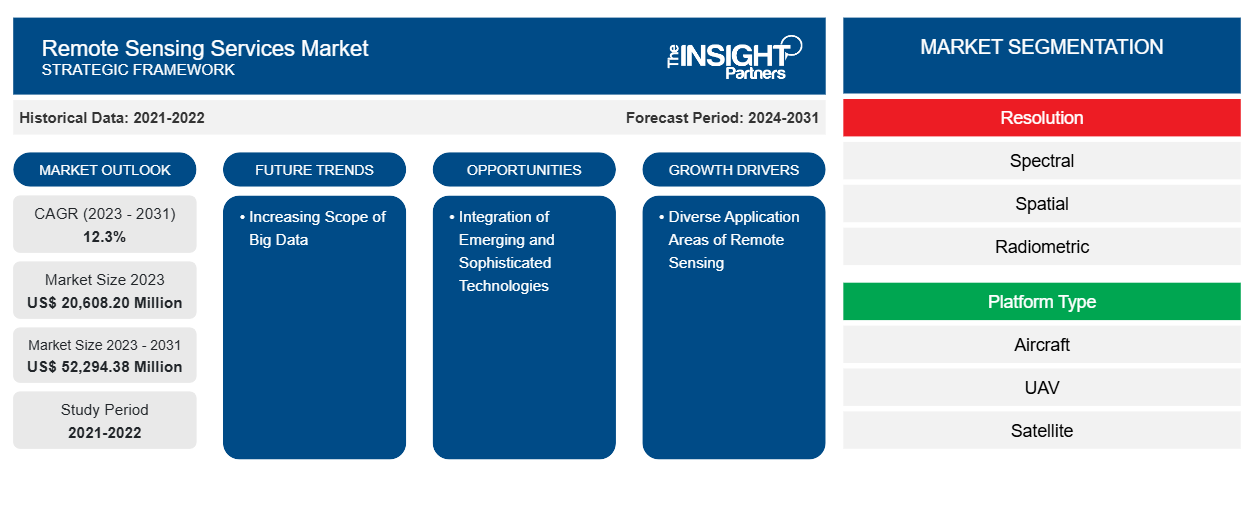
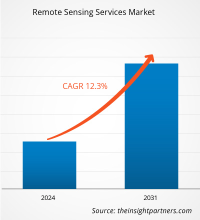
Der Markt für Fernerkundungsdienste soll von 20.608,20 Millionen US-Dollar im Jahr 2023 auf 52.294,38 Millionen US-Dollar im Jahr 2031 anwachsen. Der Markt soll zwischen 2023 und 2031 eine durchschnittliche jährliche Wachstumsrate (CAGR) von 12,3 % verzeichnen. Der zunehmende Umfang von Big Data in Fernerkundungsdiensten dürfte ein wichtiger Trend auf dem Markt bleiben.
Marktanalyse für Fernerkundungsdienste
Die Entwickler von Fernerkundungstechnologie entwickeln die Technologie zur Überwachung, Kartierung und Erkennung physikalischer Eigenschaften auf der Erdoberfläche. Später kommt der Teil der Systemintegratoren, der Satelliten, Bodenausrüstung und unbemannte Luftfahrzeuge umfasst . Die endgültige Fernerkundungstechnologie wird in Sensoren integriert, die von den genannten Systemintegratoren für ihre endgültige Verwendung in verschiedenen Teilen des Landes verwendet werden. Dieses Produkt wird mit Hilfe von Dienstleistern wie AABSyS IT bereitgestellt, um die Anforderungen der kommerziellen und Verteidigungsmärkte zu erfüllen. Der kommerzielle Markt umfasst Wetter, Forstwirtschaft, Landwirtschaft und mehr.
Marktübersicht für Fernerkundungsdienste
Der Markt für Fernerkundungsdienste besteht hauptsächlich aus Sensorherstellern, Entwicklern von Fernerkundungstechnologien, Systemintegratoren, Dienstanbietern und Endnutzern. Die Sensorhersteller produzieren aktive und passive Sensoren, die in Fernerkundungsanwendungen eingesetzt werden, die im Infrarot-, sichtbaren und Mikrowellenbereich sowie im thermischen Infrarot eines elektromagnetischen Spektrums arbeiten.
Passen Sie diesen Bericht Ihren Anforderungen an
Sie erhalten kostenlos individuelle Anpassungen an jedem Bericht, einschließlich Teilen dieses Berichts oder einer Analyse auf Länderebene, eines Excel-Datenpakets sowie tolle Angebote und Rabatte für Start-ups und Universitäten.
Markt für Fernerkundungsdienste: Strategische Einblicke
-
Holen Sie sich die wichtigsten Markttrends aus diesem Bericht.Dieses KOSTENLOSE Beispiel umfasst eine Datenanalyse von Markttrends bis hin zu Schätzungen und Prognosen.
Treiber und Chancen des Marktes für Fernerkundungsdienste
Vielfältige Anwendungsbereiche der Fernerkundung begünstigen den Markt
Zu den Nutzern von Fernerkundungsdiensten zählen das Militär, die Landwirtschafts- und Forstabteilungen sowie die Wettervorhersageabteilungen. Im Militär werden Satellitenbilder und Fernerkundung in einer breiten Palette von Anwendungen eingesetzt , darunter Aufklärung, Kartografie, Geländeanalyse, Gefechtsfeldmanagement, Verwaltung militärischer Anlagen und Überwachung terroristischer Aktivitäten. Es wird erwartet, dass die Verwendung von Fernerkundung ausgeweitet wird, um das ordnungsgemäße Funktionieren der genannten Anwendungen im Militär sicherzustellen.
Integration neuer und hochentwickelter Technologien
Die Implementierung von High-End-Technologien wie der Anwendung von Lot in der Landwirtschaft, Automatisierung, Computerbildgebung, Robotik und Fernerkundung nimmt zu. Die IoT-basierte Fernerkundung verwendet Sensoren, die in Farmen wie Wetterstationen platziert sind, um Daten zu sammeln, die zur Analyse an ein Analysetool übertragen werden. Mithilfe von Sensoren können die Landwirte ihre Ernten von einem Analyse-Dashboard aus überwachen und Entscheidungen auf der Grundlage der gesammelten Informationen treffen. Im Folgenden sind einige der Funktionen aufgeführt, die die Fernerkundung bietet. Da die Landwirte aufgrund der digitalen Umgebung immer stärker vernetzt sind, würde die hochmoderne Nutzung von Lot-, Cloud- und Fernerkundungstechnologien den Landwirten helfen, ein offenes landwirtschaftliches Ökosystem zu schaffen. Die Nutzung der High-End-Technologien erhöht die Wahrscheinlichkeit, die Nachfrage nach steigender Ernteproduktion weltweit zu erfüllen. Dieser Aspekt der Integration fortschrittlicher Technologien würde den Anwendungsbereich der Fernerkundung erweitern und so zur Marktentwicklung beitragen.
Segmentierungsanalyse des Marktberichts zu Fernerkundungsdiensten
Wichtige Segmente, die zur Ableitung der Marktanalyse für Fernerkundungsdienste beigetragen haben, sind Auflösung, Plattformtyp und Endbenutzer.
- Basierend auf der Auflösung ist der Markt für Fernerkundungsdienste in spektrale, räumliche, radiometrische und zeitliche Dienste unterteilt. Das räumliche Segment hatte im Jahr 2023 einen größeren Marktanteil.
- Basierend auf dem Plattformtyp ist der Markt für Fernerkundungsdienste in Flugzeuge, UAVs, Satelliten und Boden unterteilt. Das Satellitensegment hatte im Jahr 2023 einen größeren Marktanteil.
- Basierend auf dem Endnutzer ist der Markt für Fernerkundungsdienste in kommerzielle und militärische unterteilt. Das kommerzielle Segment hatte im Jahr 2023 einen größeren Marktanteil.
Marktanteilsanalyse für Fernerkundungsdienste nach Geografie
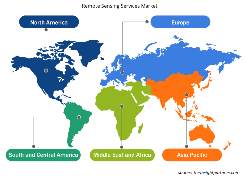
Der geografische Umfang des Marktberichts zu Fernerkundungsdiensten ist hauptsächlich in fünf Regionen unterteilt: Nordamerika, Asien-Pazifik, Europa, Naher Osten und Afrika sowie Süd- und Mittelamerika.
Der Umfang des Marktberichts zu Fernerkundungsdiensten umfasst Nordamerika (USA, Kanada und Mexiko), Europa (Russland, Großbritannien, Frankreich, Deutschland, Italien und den Rest Europas), den asiatisch-pazifischen Raum (Südkorea, Indien, Australien, Japan, China und den Rest des asiatisch-pazifischen Raums), den Nahen Osten und Afrika (Saudi-Arabien, Südafrika, die Vereinigten Arabischen Emirate und den Rest des Nahen Ostens und Afrikas) sowie Süd- und Mittelamerika (Argentinien, Brasilien und den Rest Süd- und Mittelamerikas). In Bezug auf den Umsatz dominierte Nordamerika im Jahr 2023 den Marktanteil der Fernerkundungsdienste. Europa ist der zweitgrößte Beitragszahler zum globalen Markt für Fernerkundungsdienste, gefolgt vom asiatisch-pazifischen Raum.
Regionale Einblicke in den Markt für Fernerkundungsdienste
Die regionalen Trends und Faktoren, die den Markt für Fernerkundungsdienste während des gesamten Prognosezeitraums beeinflussen, wurden von den Analysten von Insight Partners ausführlich erläutert. In diesem Abschnitt werden auch die Marktsegmente und die Geografie von Fernerkundungsdiensten in Nordamerika, Europa, im asiatisch-pazifischen Raum, im Nahen Osten und Afrika sowie in Süd- und Mittelamerika erörtert.
- Erhalten Sie regionale Daten zum Markt für Fernerkundungsdienste
Umfang des Marktberichts zu Fernerkundungsdiensten
| Berichtsattribut | Details |
|---|---|
| Marktgröße im Jahr 2023 | 20.608,20 Millionen US-Dollar |
| Marktgröße bis 2031 | 52.294,38 Millionen US-Dollar |
| Globale CAGR (2023 - 2031) | 12,3 % |
| Historische Daten | 2021-2022 |
| Prognosezeitraum | 2024–2031 |
| Abgedeckte Segmente |
Nach Auflösung
|
| Abgedeckte Regionen und Länder |
Nordamerika
|
| Marktführer und wichtige Unternehmensprofile |
|
Dichte der Marktteilnehmer für Fernerkundungsdienste: Auswirkungen auf die Geschäftsdynamik verstehen
Der Markt für Fernerkundungsdienste wächst rasant, angetrieben durch die steigende Nachfrage der Endnutzer aufgrund von Faktoren wie sich entwickelnden Verbraucherpräferenzen, technologischen Fortschritten und einem größeren Bewusstsein für die Vorteile des Produkts. Mit steigender Nachfrage erweitern Unternehmen ihr Angebot, entwickeln Innovationen, um die Bedürfnisse der Verbraucher zu erfüllen, und nutzen neue Trends, was das Marktwachstum weiter ankurbelt.
Die Marktteilnehmerdichte bezieht sich auf die Verteilung der Firmen oder Unternehmen, die in einem bestimmten Markt oder einer bestimmten Branche tätig sind. Sie gibt an, wie viele Wettbewerber (Marktteilnehmer) in einem bestimmten Marktraum im Verhältnis zu seiner Größe oder seinem gesamten Marktwert präsent sind.
Die wichtigsten auf dem Markt für Fernerkundungsdienste tätigen Unternehmen sind:
- Antrix Corporation Limited
- CyberSWIFT Infotech Pvt. Ltd.
- Geo Sense Sdn. Bhd.
- Mallon-Technologie
- EKOFAST SL
- Satellitenbildgebungsgesellschaft
Haftungsausschluss : Die oben aufgeführten Unternehmen sind nicht in einer bestimmten Reihenfolge aufgeführt.
- Überblick über die wichtigsten Akteure auf dem Markt für Fernerkundungsdienste
Marktnachrichten und aktuelle Entwicklungen im Bereich Fernerkundungsdienste
Der Markt für Fernerkundungsdienste wird durch die Erhebung qualitativer und quantitativer Daten nach Primär- und Sekundärforschung bewertet, die wichtige Unternehmensveröffentlichungen, Verbandsdaten und Datenbanken umfasst. Nachfolgend sind einige der Entwicklungen auf dem Markt für Fernerkundungsdienste aufgeführt:
- Mallon Technology gewann den Preis in der Kategorie „Bester Service“ bei den GO Awards Northern Ireland 2020. Der Preis wird für den hervorragenden Kundenservice des Unternehmens gewürdigt. (Quelle: Mallon Technology, Pressemitteilung, März 2020)
- NorthStar Earth & Space Inc. gab eine strategische Geschäftspartnerschaft mit SpecTIR Hyperspectral & Remote Sensing Solutions aus Reno, Nevada, bekannt, um umfassende hyperspektrale Bildgebungsdienste anzubieten. Die luftgestützten hyperspektralen Bilddienste von SpecTIR ergänzen die weltraumgestützten hyperspektralen Bilddienste von NorthStar, der weltweit ersten globalen Informationsplattform zur Überwachung der Erde, ihrer Umwelt und des erdnahen Weltraums. (Quelle: SpecTIR, Pressemitteilung, Januar 2019)
Marktbericht zu Fernerkundungsdiensten – Umfang und Ergebnisse
Der Bericht „Marktgröße und Prognose für Fernerkundungsdienste (2021–2031)“ bietet eine detaillierte Analyse des Marktes, die die folgenden Bereiche abdeckt:
- Marktgröße und Prognose für Fernerkundungsdienste auf globaler, regionaler und Länderebene für alle wichtigen Marktsegmente, die im Rahmen des Berichts abgedeckt sind
- Markttrends und Marktdynamiken für Fernerkundungsdienste wie Treiber, Einschränkungen und wichtige Chancen
- Detaillierte PEST- und SWOT-Analyse
- Marktanalyse für Fernerkundungsdienste, die wichtige Markttrends, globale und regionale Rahmenbedingungen, wichtige Akteure, Vorschriften und aktuelle Marktentwicklungen umfasst
- Branchenlandschaft und Wettbewerbsanalyse, die die Marktkonzentration, Heatmap-Analyse, prominente Akteure und aktuelle Entwicklungen auf dem Markt für Fernerkundungsdienste umfasst
- Detaillierte Firmenprofile

Naveen ist ein erfahrener Marktforschungs- und Beratungsexperte mit über 9 Jahren Erfahrung in kundenspezifischen, syndizierten und Beratungsprojekten. In seiner aktuellen Funktion als Associate Vice President hat er erfolgreich Stakeholder entlang der gesamten Projektwertschöpfungskette gemanagt und ist Autor von über 100 Forschungsberichten und über 30 Beratungsaufträgen. Seine Arbeit erstreckt sich auf Industrie- und Regierungsprojekte und trägt maßgeblich zum Kundenerfolg und zur datengesteuerten Entscheidungsfindung bei.
Naveen hat einen Ingenieursabschluss in Elektronik und Kommunikation von der VTU, Karnataka, und einen MBA in Marketing und Operations von der Manipal University. Er ist seit 9 Jahren aktives IEEE-Mitglied und nimmt an Konferenzen und technischen Symposien teil und engagiert sich ehrenamtlich auf Sektions- und regionaler Ebene. Vor seiner aktuellen Position arbeitete er als Associate Strategic Consultant bei IndustryARC und als Industrial Server Consultant bei Hewlett Packard (HP Global).
- Umfassende Analyse der Marktgröße und Prognosen
- Detaillierte Segmentierungsanalyse
- Tiefgehende Bewertung der Marktdynamik
- Einblicke auf regionaler und nationaler Ebene
- Wettbewerbslandschaft und Unternehmens-Benchmarking
- Strategische Business Intelligence
Erfahrungsberichte
Der SCADA-Systemmarktbericht von Insight Partners ist umfassend und bietet wertvolle Einblicke in aktuelle Trends und Zukunftsprognosen. Das Team war durchweg hochprofessionell, reaktionsschnell und hilfsbereit. Wir sind sehr zufrieden und können die Dienstleistungen wärmstens empfehlen.
RAN KEDEM Partner, Reali Technologies LTDsIch habe einen Bericht über einen sehr spezifischen Softwaremarkt angefordert, und das Team hat ihn innerhalb weniger Tage erstellt. Die Informationen waren sehr relevant und gut präsentiert. Anschließend habe ich einige Änderungen und Ergänzungen zum Bericht angefordert. Das Team reagierte erneut sehr schnell, und ich erhielt den Abschlussbericht in weniger als einer Woche.
JEAN-HERVE JENN Vorsitzende, Future AnalyticaWir haben mit The Insight Partners für eine wichtige Marktstudie und Prognose zusammengearbeitet. Sie gaben uns klare Einblicke in Chancen und Risiken, die uns bei der Gestaltung unserer Pläne halfen. Ihre Recherchen waren benutzerfreundlich und basierten auf soliden Daten. Sie halfen uns, kluge und sichere Entscheidungen zu treffen. Wir können sie wärmstens empfehlen.
PIYUSH NAGPAL Sr. Vizepräsident, Fernlicht GlobalDie Insight Partners lieferten aufschlussreiche, gut strukturierte Marktforschung mit fundierter Fachkompetenz. Ihr Team war durchweg professionell und reaktionsschnell. Die benutzerfreundliche Website ermöglichte den Zugriff auf Branchenberichte. Wir empfehlen sie wärmstens für zuverlässige und hochwertige Forschungsdienstleistungen.
YUKIHIKO ADACHI Geschäftsführer, Deep Blue, LLC.Dies ist das erste Mal, dass ich einen Marktbericht von The Insight Partners erworben habe. Obwohl ich zunächst unsicher war, besuchte ich die Website und fühlte mich dann sicherer, das Risiko einzugehen und einen Marktbericht zu kaufen. Ich bin mit der Qualität des Berichts und dem Kundenservice rundum zufrieden. Ich hatte einige Fragen und Anmerkungen zum ersten Bericht, aber nach einigen E-Mail-Gesprächen mit dem Analysten bin ich überzeugt, dass ich einen Bericht habe, den ich als Input für unseren strategischen Planungsprozess verwenden kann. Vielen Dank, dass Sie sich die Zeit genommen und dies zu einer positiven Erfahrung gemacht haben. Ich werde Ihren Service auf jeden Fall weiterempfehlen und Sie werden meine erste Anlaufstelle sein, wenn wir weitere Marktdaten benötigen.
JOHN SUZUKI Präsident und Chief Executive Officer, Vorstandsmitglied, BK TechnologiesIch möchte mich für Ihre Unterstützung und die Professionalität bedanken, die Sie bei der Bearbeitung meiner Informationsanfrage zum IVD-Markt für Infektionskrankheiten in Nigeria gezeigt haben. Ich schätze Ihre Geduld, Ihre Beratung und die Tatsache, dass Sie bereit waren, einen Rabatt anzubieten, der uns schließlich den Abschluss eines Geschäfts ermöglichte. Ich freue mich darauf, The Insight Partners in Zukunft wieder zu beauftragen, dank des Eindrucks, den Sie bei dieser ersten Begegnung bei mir hinterlassen haben.
DR. CHIJIOKE ONYIA GESCHÄFTSFÜHRERIN, PineCrest Healthcare Ltd.Grund zum Kauf
- Fundierte Entscheidungsfindung
- Marktdynamik verstehen
- Wettbewerbsanalyse
- Kundeneinblicke
- Marktprognosen
- Risikominimierung
- Strategische Planung
- Investitionsbegründung
- Identifizierung neuer Märkte
- Verbesserung von Marketingstrategien
- Steigerung der Betriebseffizienz
- Anpassung an regulatorische Trends