
3D Mapping and Modelling Market Growth Drivers and Forecast by 2034
Coverage: By Deployment Mode ( Cloud and On-premises), Organization Size (SMEs and Large Enterprises), Component (Software Tools and Services), 3D Mapping Application (Inspection and Measurement, Object Reconstruction, Projection and Navigation, Reporting and Virtualization, and Other 3D Mapping Applications), 3D Modelling Application (Product Marketing, Animation and Movies, Gaming and Designing, Architectural Rendering, and Other 3D Modelling Applications), and Vertical (Retail and Consumer Goods, Engineering and Construction, Healthcare and Life Sciences, Transportation and Logistics, Government and Defence, Energy and Utilities, Media and Entertainment, Manufacturing, and Other Verticals), and by Geography
- Status : Data Released
- Report Code : TIPTE100000786
- Category : Technology, Media and Telecommunications
- No. of Pages : 150
- Available Report Formats :


- Last update date : August 05, 2026


2025 Market Size
US$ 7.15 Bn
Base year value
2034 Forecast
US$ 30.80 Bn
Projected by 2034
CAGR 2026-2034
17.61 %
Growth rate
Addressable Market
US$ 157.83 Bn
(2026-2034)
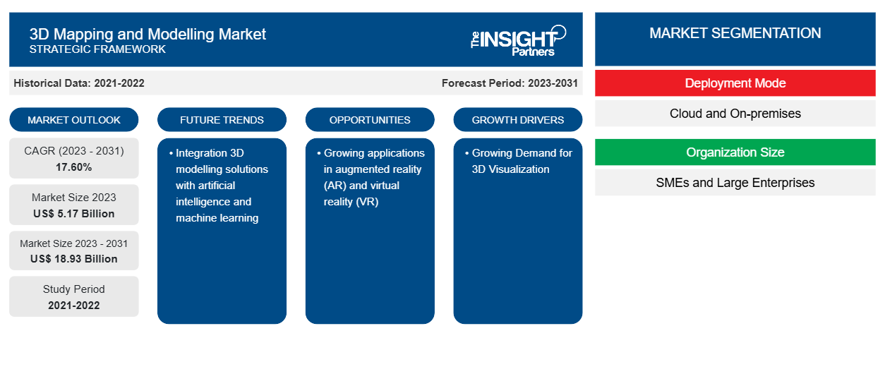
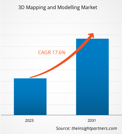
The 3D mapping and modelling market was valued at US$ 7.15 Billion in 2025 and is projected to reach US$ 30.80 Billion by 2034, registering a CAGR of 17.61% during 2026–2034. Market expansion is being supported by increasing deployment of digital twin platforms, geospatial intelligence solutions, infrastructure modernization initiatives, and autonomous navigation technologies. Advancements in LiDAR systems, drone-based surveying, photogrammetry software, and cloud computing capabilities continue to broaden application areas across public and private sectors worldwide.
Throughout North America, adoption remains fueled by transportation modernization, utility network digitization, defense mapping programs, and smart infrastructure development. The 3D mapping and modelling market size across the region benefits from extensive GIS implementation, favorable drone regulations, and widespread use of engineering software platforms. Strong investments in digital asset management and reality capture technologies are expected to support a 15.5–18.5% CAGR during the forecast period.
3D Mapping and Modelling Market Assessment and Insights
- North America: Share in 2025 estimated at 34–38%, supported by infrastructure digitization, transportation modernization, defense intelligence programs, and advanced engineering software adoption. CAGR between 2026–2034: 15.5–18.5%.
- US: Accounts for 72–78% of North American demand in 2025, driven by construction technology spending, public infrastructure investments, and strong geospatial software ecosystems. CAGR between 2026–2034: 15–18%.
- Europe: Share in 2025 estimated at 25–29%. Germany, the UK, and France lead demand through industrial engineering, smart mobility, and infrastructure management applications. CAGR between 2026–2034: 15–18%.
- Asia Pacific: Share in 2025 estimated at 28–32%. China, Japan, South Korea, India, and Australia continue investing in smart cities, transportation planning, and digital construction initiatives. CAGR between 2026–2034: 19–22%.
- Largest Segment: Cloud deployment accounts for 58–62% market share in 2025 because of scalable data storage, efficient processing, and collaborative project management. CAGR between 2026–2034: 18–21%.
- High Growth Segment: Projection and Navigation represents 18–22% market share in 2025 and is expected to advance at 20–23% CAGR through 2034 due to autonomous mobility adoption.
- Key companies analyzed in detail: Autodesk, Saab AB, Golden Software LLC, Trimble Inc., Bentley Systems Incorporated, Alphabet Inc., Intermap Technologies Corporation, Airbus SE, Esri Inc., CyberCity 3D Inc., Spine 3D, Cad Crowd LLC, VegaCADD, MAP Systems, Kevuru Games, Energy Dais, Brightscout, UFO 3D.
Source: The Insight Partners' analysis based on proprietary research, government publications, company annual reports, investor presentations, industry databases, and expert interviews.
The 3D mapping and modelling market has progressed significantly from traditional surveying and mapping workflows toward integrated digital ecosystems capable of supporting infrastructure management, urban planning, industrial monitoring, and transportation optimization. Continuous improvements in sensor technologies, cloud computing environments, and data visualization capabilities have reduced implementation barriers while increasing the accuracy and operational value of three-dimensional geospatial datasets.
Looking ahead, growth is likely to be supported by rising investments in smart infrastructure, national digital twin initiatives, and modernization of public asset management systems. Emerging economies are increasingly incorporating digital engineering practices into development strategies, while artificial intelligence and automated reconstruction technologies are expected to improve scalability and expand commercial use cases across multiple sectors.
3D Mapping and Modelling Market Report Scope
| Report Attribute | Details |
|---|---|
| Market size in 2025 | US$ 7.15 Billion |
| Market Size by 2034 | US$ 30.80 Billion |
| Global CAGR (2026 - 2034) | 17.61% |
| Historical Data | 2021-2024 |
| Forecast period | 2026-2034 |
3D Mapping and Modelling Market Analysis
The 3D mapping and modelling market growth is strongly influenced by the growing requirement for highly accurate geospatial intelligence across transportation, energy, utilities, construction, mining, and defense industries. Organizations increasingly rely on three-dimensional data environments to improve planning accuracy, reduce operational risks, and enhance asset performance management. Growing complexity within infrastructure projects has increased demand for precise spatial representation and real-time visualization capabilities.
A broad ecosystem supports market development, including drone manufacturers, LiDAR sensor suppliers, satellite imagery providers, software developers, cloud platform operators, engineering consultancies, and geospatial service companies. Demand for digital twins, predictive maintenance systems, and automated inspection technologies is encouraging greater adoption of advanced modeling solutions. As organizations produce larger data volumes, cloud-enabled processing frameworks are becoming increasingly important in maintaining operational efficiency.
The 3D mapping and modelling market analysis highlights a competitive environment focused on software innovation, platform interoperability, and advanced visualization capabilities. Vendors are prioritizing investments in artificial intelligence, automation, and cloud-native architectures that enable enterprises to process, analyze, and manage large-scale geospatial datasets more efficiently.
Autodesk, Bentley Systems Incorporated, Trimble Inc., Airbus SE, and Esri Inc. continue to strengthen their market positions through comprehensive product ecosystems and established enterprise relationships. Alphabet Inc. maintains influence through location intelligence capabilities, while Intermap Technologies Corporation and CyberCity 3D Inc. contribute specialized geospatial content and modeling expertise. Strategic partnerships and targeted acquisitions remain important mechanisms for expanding capabilities, enhancing geographic reach, and improving industry-specific solution offerings.
● REPORT CUSTOMIZATION
Tailor This Report To Align With Your Specific Business Requirements
This report can be customized to align precisely with your business objectives, scope, and target markets. Customization options include tailored segmentation, geography, competitive analysis, and strategic insights to support informed decision-making.
Customize This Report →WHAT YOU CAN ADJUST
- ● Segmentations
- ● Geography
- ● Competitive Analysis
- ● Language Preferences
3D Mapping and Modelling Market: Strategic Insights
Regional Insights
North America 3D mapping and modelling market
North America accounted for approximately 34–38% of global revenue in 2025, making it the largest regional market and giving it the dominant 3D mapping and modelling market share. Strong investments in transportation infrastructure, utility modernization, digital construction platforms, and defense intelligence systems continue to support demand. Widespread adoption of GIS technologies and cloud-based engineering tools has accelerated implementation across both government and enterprise environments.
Regional growth is expected to remain within a 15.5–18.5% CAGR range through 2034. Public agencies increasingly rely on geospatial intelligence to improve planning and operational efficiency, while private organizations are using advanced visualization tools to optimize infrastructure and asset management programs. The expanding role of digital twins in transportation, utilities, and industrial facilities continues to strengthen long-term demand.
U.S. 3D mapping and modelling Market
The United States represents approximately 72–78% of North American demand and is projected to expand at a 15–18% CAGR during the forecast period. Infrastructure investment programs, utility network upgrades, and growing adoption of reality capture technologies support steady demand across federal, state, and private-sector organizations. Transportation authorities, engineering firms, and telecommunications providers remain among the most active adopters.
A large concentration of industry participants, including Autodesk, Bentley Systems Incorporated, Esri Inc., and Trimble Inc., supports continuous technology innovation. Demand is expanding beyond conventional surveying into digital twin management, predictive maintenance, public safety planning, and autonomous mobility applications. Cloud geospatial platforms continue gaining traction because of their scalability and collaborative capabilities.
Europe 3D mapping and modelling Market
Europe represented approximately 25–29% of global revenue in 2025 and is expected to register a 15–18% CAGR through 2034. Regional growth is supported by infrastructure modernization programs, environmental monitoring initiatives, and increasing use of digital engineering technologies across transportation and industrial sectors. Germany remains the leading country because of its advanced manufacturing base and engineering expertise.
The United Kingdom continues expanding smart city deployments and transportation digitization projects that require advanced geospatial datasets and visualization tools. Germany maintains leadership through broad adoption of digital twin and industrial planning technologies. France, Italy, and Spain are increasingly deploying three-dimensional mapping solutions to support renewable energy projects, urban planning initiatives, rail modernization, and utility infrastructure management. Combined public and private investments are expected to sustain regional demand throughout the assessment period.
APAC 3D mapping and modelling Market
Asia Pacific accounted for approximately 28–32% of 3D mapping and modelling market revenue in 2025 and is forecast to achieve the highest regional growth at 19–22% CAGR through 2034. China remains the largest contributor due to extensive investments in smart cities, transportation infrastructure, and digital urban management systems.
Japan, South Korea, India, and Australia continue investing in digital engineering, disaster management, infrastructure planning, and next-generation mobility solutions. Government-led digitization programs and strong construction activity support increasing adoption across public-sector and commercial applications.
Middle East & Africa 3D mapping and modelling Market
The Middle East & Africa market is expected to expand at a 16–19% CAGR through the forecast period. Regional demand is driven by infrastructure development, urban transformation projects, and growing use of geospatial intelligence in transportation and energy sectors.
Saudi Arabia and the UAE lead adoption through large-scale development programs, smart city initiatives, and significant capital investments in digital infrastructure. South Africa contributes through mining, utilities, and engineering applications, while broader regional demand continues to expand with modernization efforts across key industries.
Segmentation Analysis
Deployment Mode
Deployment Mode is projected to record a CAGR of 18–21% during 2026–2034. Enterprises are increasingly selecting deployment environments based on scalability requirements, data security needs, processing volumes, and collaboration objectives. The transition toward cloud-native geospatial ecosystems is improving accessibility and reducing infrastructure costs, while organizations handling sensitive information continue to maintain dedicated in-house systems. Both deployment models remain critical to the overall market landscape, serving distinct operational and compliance requirements across industries.
- Cloud: The leading deployment category due to its ability to process large geospatial datasets efficiently while enabling real-time collaboration among distributed project teams. Organizations benefit from scalable computing resources, simplified updates, and reduced infrastructure management burdens.
- On-premises: Continues to serve government agencies, defense organizations, critical infrastructure operators, and highly regulated industries where data sovereignty, cybersecurity controls, and customized system integration remain strategic priorities for operational continuity.
Component
Component is anticipated to expand at a CAGR of 17–20% during 2026–2034. Increasing demand for comprehensive geospatial intelligence solutions is driving investment in both software platforms and specialized services. Organizations require integrated ecosystems that support data acquisition, processing, visualization, analysis, deployment, and maintenance. As implementation complexity increases, service providers play a growing role in ensuring successful adoption and long-term operational performance.
- Software Tools: Represent the largest revenue contributor within the segment because they support core functions such as spatial modeling, visualization, mapping, analytics, simulation, and digital twin development across multiple industry verticals.
- Services: Demand remains strong for consulting, implementation, integration, maintenance, customization, technical support, and managed geospatial operations that help organizations maximize software effectiveness and return on investment.
Application
Application is expected to grow at a CAGR of 18–22% during 2026–2034. Expanding applications across transportation, infrastructure management, utilities, construction, energy, and public administration continue to strengthen segment growth. Organizations are increasingly leveraging advanced mapping environments to improve decision-making, optimize assets, reduce project risks, and enhance operational visibility. Improvements in automation, artificial intelligence, and sensing technologies are creating new opportunities for application-specific deployments.
- Inspection and Measurement: Maintains a strong position due to widespread use in infrastructure assessment, asset condition monitoring, engineering verification, utility inspections, and project quality control activities requiring high spatial accuracy.
- Object Reconstruction: Widely utilized for creating detailed digital representations of buildings, industrial facilities, cultural heritage sites, manufactured assets, and complex physical environments requiring realistic visualization and simulation.
- Projection and Navigation: The fastest-growing application category, benefiting from increasing deployment in autonomous mobility systems, intelligent transportation networks, robotics, advanced logistics operations, and real-time route optimization platforms.
- Reporting and Virtualization: Supports stakeholder communication, project visualization, digital twin management, scenario planning, and immersive presentation environments that improve collaboration and planning efficiency across organizations.
Opportunity Snapshot
| Application | Revenue Contribution | Trend Tag | Adoption Stage |
| Inspection and Measurement | High | Asset Monitoring | Mature |
| Object Reconstruction | Medium | Digital Twin | Scaling |
| Projection and Navigation | High | Autonomous Mobility | Scaling |
| Reporting and Virtualization | Medium | Immersive GIS | Scaling |
| Other 3D Mapping Applications | Low | Niche Models | Emerging |
3D Mapping and Modelling Market Growth Drivers and Impact Analysis
Expansion of Digital Twin Infrastructure Programs
Governments, infrastructure operators, and industrial organizations are increasingly investing in digital twin ecosystems to improve asset visibility, maintenance efficiency, and long-term lifecycle management. 3D mapping and modeling capabilities have become the building blocks of digital twin technology, enabling the creation of detailed, accurate maps of the physical world and infrastructure. Transport systems, utilities, airports, factories, and smart cities are just some examples of key application areas where the trend is evident. There is an increasing need to ensure that infrastructure operations are monitored and optimized by reducing operational disruptions. This is fueling the requirement for sophisticated geospatial intelligence solutions. Infrastructure modernization plans in developed and emerging countries are driving the adoption of reality capture and visualization technologies.
Rapid Growth of Drone-Based Data Acquisition and LiDAR Deployment
The growing availability of commercial drones and sophisticated LiDAR technology has changed the way businesses gather spatial data. Compared with conventional surveying approaches, drone mapping technologies offer faster implementation, a much larger geographic scope, and greater efficiency. The sectors employing aerial reality-capturing devices to support decision-making and shorten project durations include construction, energy, mining, agriculture, telecommunications, and infrastructure management, among others. Advancements in sensor technology and reductions in hardware costs have made data collection accessible to a larger number of companies, including mid-size and regional ones. With increased data-gathering frequency and lower costs, there is greater demand for platforms to process, visualize, and analyze data.
Growing Demand for Spatial Intelligence in Transportation and Mobility
The transportation industry, logistics companies, and mobility technology firms increasingly rely on an accurate three-dimensional environment to improve planning, efficiency, and safety outcomes. The mapping tools support asset inspection, route optimization, traffic management, infrastructure monitoring, and autonomous navigation. Given the significant investments governments make to enhance transportation systems and intelligent mobility, demand for geospatial intelligence is likely to rise. Self-driving cars, transportation systems, robotics, and drone systems depend on highly accurate mapping data to operate effectively. Moreover, the integration of IoT sensors, predictive maintenance, and real-time monitoring technologies makes three-dimensional models even more valuable.
3D Mapping and Modelling Market Future Trends
AI-Driven Spatial Reconstruction and Automated Modeling
The 3D mapping and modelling market trends indicate a growing shift toward artificial intelligence-driven reconstruction platforms capable of automating traditionally labor-intensive mapping workflows. Future solutions are expected to leverage machine learning technologies for tasks such as object recognition, point cloud classification, feature extraction, anomaly detection, and automated modeling. This will greatly help in saving processing time and ensure efficiency and scalability. Companies handling large infrastructure, urban areas, and industrial resources will enjoy a much quicker turnaround time in their data analysis. With advances in cloud computing and reduced computing costs, AI-enabled mapping solutions will gain ground across sectors. The vendors will target real-time reconstruction of imagery and sensor data.
Convergence of GIS, BIM, Digital Twins, and Reality Capture
A key future trend is the integration of geographic information systems, building information modeling, digital twin platforms, and reality capture technologies into a single operational environment. More and more companies want centralized ecosystems that allow them to plan, build, operate, maintain, and optimize their infrastructure from a single source of information. Such unification will help increase interoperability across departments and address problems associated with non-integrated information sources. Owners of infrastructure facilities, city administrators, utilities, and engineering companies will prefer platforms that integrate geospatial information with operations. The development of standards for data exchange will likely necessitate the integration of digital ecosystems in the future.
3D Mapping and Modelling Market Opportunities
Smart City and Urban Digital Infrastructure Expansion
Urbanization continues to create substantial opportunities for organizations delivering advanced geospatial intelligence, visualization, and spatial analytics solutions. Governments worldwide are investing in smart city programs designed to improve transportation management, utility operations, environmental monitoring, public safety, and resource optimization. These initiatives require highly accurate digital representations of urban environments that can support planning, simulation, and operational decision-making. Three-dimensional mapping and modeling technologies enable city administrators to evaluate infrastructure performance, assess development scenarios, and improve service delivery. Technology providers capable of combining mapping, analytics, cloud infrastructure, and digital twin capabilities are well positioned to benefit from long-term implementation projects. In addition, recurring requirements for data updates, asset monitoring, and visualization services create ongoing revenue opportunities throughout the lifecycle of smart city programs, making this one of the most attractive long-term growth areas within the market.
Autonomous Navigation and Connected Mobility Ecosystems
The continued evolution of autonomous vehicles, robotics platforms, intelligent transportation systems, and unmanned aerial operations presents a significant commercial opportunity for market participants. The development of sophisticated navigation systems depends on precise, frequently updated 3D spatial datasets that enable localization, route optimization, obstacle detection, and overall safety. In view of increasing connectivity within mobility networks, the quality of the geospatial data is going to become increasingly important. Companies that can supply navigation-quality maps, up-to-date environmental information, and a scalable cloud platform for processing data are bound to have an edge. Collaboration with automotive companies, logistics firms, robotics companies, and transport authorities might help to speed up adoption. The expansion of connected infrastructure and the development of future mobility platforms will ensure continued demand.
Frequently Asked Questions

- Comprehensive Market Sizing and Forecast Analysis
- Detailed Segmentation Analysis
- In-Depth Market Dynamics Assessment
- Regional and Country-Level Insights
- Competitive Landscape and Company Benchmarking
- Strategic Business Intelligence
Recent Reports
Testimonials

The Insight Partners' SCADA System Market report is comprehensive, with valuable insights on current trends and future forecasts. The team was highly professional, responsive, and supportive throughout. We are very satisfied and highly recommend their services.
RAN KEDEM Partner, Reali Technologies LTDs
I requested a report on a very specific software market and the team produced the report in a few days. The information was very relevant and well presented. I then requested some changes and additions to the report. The team was again very responsive and I got the final report in less than a week.
JEAN-HERVE JENN Chairman, Future Analytica
We worked with The Insight Partners for an important market study and forecast. They gave us clear insights into opportunities and risks, which helped shape our plans. Their research was easy to use and based on solid data. It helped us make smart, confident decisions. We highly recommend them.
PIYUSH NAGPAL Sr. Vice President, High Beam Global
The Insight Partners delivered insightful, well-structured market research with strong domain expertise. Their team was professional and responsive throughout. The user-friendly website made accessing industry reports seamless. We highly recommend them for reliable, high-quality research services
YUKIHIKO ADACHI CEO, Deep Blue, LLC.
This is the first time I have purchased a market report from The Insight Partners.While I was unsure at first, I visited their web site and felt more comfortable to take the risk and purchase a market report.I am completely satisfied with the quality of the report and customer service. I had several questions and comments with the initial report, but after a couple of dialogs over email with their analyst I believe I have a report that I can use as input to our strategic planning process.Thank you so much for taking the extra time and making this a positive experience.I will definitely recommend your service to others and you will be my first call when we need further market data.
JOHN SUZUKI President and Chief Executive Officer, Board Director, BK Technologies
I wish to appreciate your support and the professionalism you displayed in the course of attending to my request for information regarding to infectious disease IVD market in Nigeria. I appreciate your patience, your guidance, and the fact that you were willing to offer a discount, which eventually made it possible for us to close a deal. I look forward to engaging The Insight Partners in the future, all thanks to the impression you have created in me as a result of this first encounter.
DR CHIJIOKE ONYIA MANAGING DIRECTOR, PineCrest Healthcare Ltd.Reason to Buy
- Informed Decision-Making
- Understanding Market Dynamics
- Competitive Analysis
- Identifying Emerging Markets
- Customer Insights
- Market Forecasts
- Risk Mitigation
- Boosting Operational Efficiency
- Strategic Planning
- Investment Justification
- Tracking Industry Innovations
- Aligning with Regulatory Trends





 Get Free Sample for